-
Bug
-
Resolution: Done
-
 P2: Important
-
5.10.0
-
None
-
Linux/MacOS
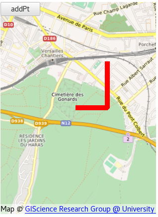
Based on this sample code:
Item {
  Plugin {
    id: mapPlugin
    name: "osm"
  }
  Map {
    id: map
    anchors.fill: parent
    plugin: mapPlugin
    center: QtPositioning.coordinate(48.79, 2.14)
    zoomLevel: 14

    MapPolyline {
      id: mpl
      line.color: 'red'
      line.width: 10
      path: [
        QtPositioning.coordinate(48.79, 2.14),
        QtPositioning.coordinate(48.79, 2.145),
        QtPositioning.coordinate(48.795, 2.145)
      ]
    }

    Button {
      text: "addPt"
      onClicked: {
        mpl.addCoordinate(QtPositioning.coordinate(48.78, 2.12))
      }
    }
  }
}
First you get this display "Capture d'écran de 2018-02-26 15-17-30.png" => correct
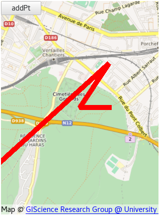
After hitting the button "addPt" you view "Capture d'écran de 2018-02-26 15-17-34.png" => incorrect (1st points is swapped)
If you provide directly the coordinate (48.78, 2.12) at the end of the path definition, the display is directly the wrong one.
| For Gerrit Dashboard: QTBUG-66692 | ||||||
|---|---|---|---|---|---|---|
| # | Subject | Branch | Project | Status | CR | V |
| 221553,31 | Fix Clipper screwing polyline topology during clipping | 5.11 | qt/qtlocation | Status: MERGED | -2 | 0 |
| 221555,1 | Fix Clipper screwing polyline topology during clipping | dev | qt/qtlocation | Status: ABANDONED | 0 | 0 |