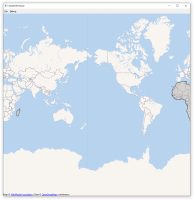
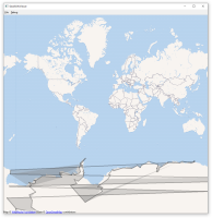
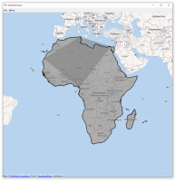
The example GeoJSON Viewer can be used to visualize geographic shapes in from of GeoJSON files. Some examples are not rendered as expected and as on other platforms.
The following unexpected behavior was found:
- If a MapPolygon should appear on both sides of the map (the map is periodic between -180 and 180) it appears only on one side of the map.
- If a MapPolygon is crossing the "date line" (longitude = -180 = 180) multiple times it is not rendered correctly.
- Complex MapPolygons are not rendered correctly at some zoom levels.
The error can be reproduced with the appended GeoJson files. The continent shapes are taken from https://gist.github.com/hrbrmstr/91ea5cc9474286c72838?short_path=f3fde31. They are verified with QGis.
| For Gerrit Dashboard: QTBUG-110511 | ||||||
|---|---|---|---|---|---|---|
| # | Subject | Branch | Project | Status | CR | V |
| 456598,26 | Correct and improve the rendering of QuickMapItems | dev | qt/qtlocation | Status: MERGED | +2 | 0 |
| 460385,2 | Correct and improve the rendering of QuickMapItems | 6.5 | qt/qtlocation | Status: MERGED | +2 | 0 |


